"When you find my body, please call my husband George ... and my daughter Kerry. It will be the greatest kindness for them to know that I am dead where you found me -- no matter how many years from now." [Journal entry left by Gerry Largay – August 2013]
An unsuccessful search
Geraldine (Gerry) Largay, also known on the trail as Inchworm, was officially declared missing on July 25, 2013. The last entry into her hand-written journal was dated August 18, 24 days after she became lost in the rugged and tangled forests of Maine while hiking the Appalachian Trail. Once Gerry realized that she was in trouble, she attempted to send text messages almost a dozen times to her husband George, always asking for help, while continuing to seek higher ground. Unfortunately, none of her messages would ever be received.
Even though the largest search and rescue operation in Maine’s history was happening all around her, it was all to be for naught. In the end, Inchworm would not be saved by her own efforts nor by the efforts of thousands of well-intended searchers trying to bring her home. It would not be until October 2015, some 2 years later, when Gerry’s last campsite would be found, entirely by chance during a land survey, well inside the search area. Her last campsite was sadly only about 3000 feet away from the trail where she had originally been hiking.
Opportunity to discover
Rick McAllister and I were discussing the value of the ThinkReliability Cause Mapping approach during a workshop in Florida when he brought this story to my attention. I did some initial research and the story broke my heart. The rescuers came so close to her location several times.
As with all of my investigations, I began to ask “Why?” questions. Why were the canine teams unsuccessful? Why were the human teams unsuccessful? Why were the aerial efforts unsuccessful? Why wasn’t more importance given to an electronic cell phone ping location that was acquired? Perhaps developing a Cause Map could reveal opportunities to improve survivability.
Together, Rick, ThinkReliability instructor and investigator Sarah Wrenn and I, put the Cause Mapping method to work to create a Cause Map.
The first step in the Cause Mapping method is to define the problem by filling in an outline with the basic background information. Then, we ask ourselves “how did this incident negatively impact our company’s goals?” There is an impact to the safety goals and the labor goals regarding resource hours. Capturing all of the impacted goals helps to quantify the problems and ensures that all facets of the issue are considered during the analysis. Click on the thumbnail below to view the PDF.
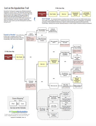
Causes
The hiker: An important element of the Cause Mapping method is finding the system of causes for an event rather than focusing on “the root cause” or the blame. Part of the system for this event includes decisions made by the hiker. Ms. Largay brought an inaccurate compass, and she left her satellite transponder in her hotel room.
She was hiking with a companion but when her companion had to abandon the hike due to a family emergency, Gerry kept going alone. It is hypothesized that she developed “Target Fixation.” Hikers often call this “Summit Fever.” Reaching the goal, completing the Appalachian Trail in Gerry’s case, becomes so important that the hiker does not recognize or chooses to ignore hazards along the way.
Gerry was not trained to identify and use possible food sources. She was not trained to identify wood that would make sufficient smoke for rescuers to see. Her survival for over 24 days was remarkable and a credit to her wit and will; however, training would have benefitted her greatly.
The search: Factors which contributed to the search being unsuccessful include a series of false tips which lead to the diversions of resources to those “hot tips.” Heavy wind and rain also contributed to the K9 (Dog-Human) teams’ difficulties in locating the missing hiker. A cell phone triangulation ping to the Verizon device she was using revealed a location that was not far from where her body was discovered.
Solutions: Once a system of causes is identified, the Cause Mapping method then leads to identifying possible solutions. The three of us brainstormed potential solutions.
- Some kind of professional certification program (perhaps modeled after the certification for SCUBA Divers – PADI) for hikers would be advantageous.
- Different skill levels could include group hiker, buddy hiker, lone hiker with recommendations for the difficulty level, length and duration of the hike would increase safety for the hikers and search and rescue personnel.
- Training in use of equipment (compass, satellite transponder), best practices (avoid target fixation) and strategies to aid rescue (brightly colored tent, rescue fire building, survival skills) would have increased the chance of a successful rescue.
- A packing checklist that included a Satellite Transponder and an improved compass with a lubber line could be used to help reduce a hiker’s risk.