
Explore More Aviation Case Studies & Examples
On the night of January 29th, 2025, a catastrophic mid-air collision occurred over the approach to Ronald Reagan Washington National Airport (DCA). American Airlines Flight 5342 and a military Black Hawk helicopter collided, resulting in 67 fatalities.
This tragic event has raised questions about air traffic control procedures, situational awareness, and risk management in congested airspace. The public is seeking answers, but the speculation and misinformation that erupted in the immediate aftermath continue to cloud the narrative.
What Happened?
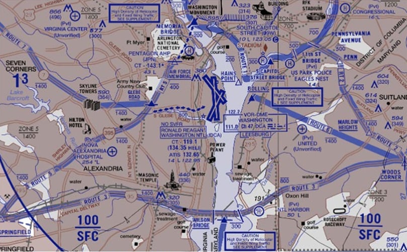
American Airlines Flight 5342 (AA5342, a CRJ-700) was on the TRUPS FIVE1 arrival procedure, initially cleared for runway 01 at DCA. However, Air Traffic Control (ATC) later reassigned the aircraft to runway 33.
DCA Runway 01 & DCA Runway 33 Approach (Images by FAA, Annotated by ThinkReliability)
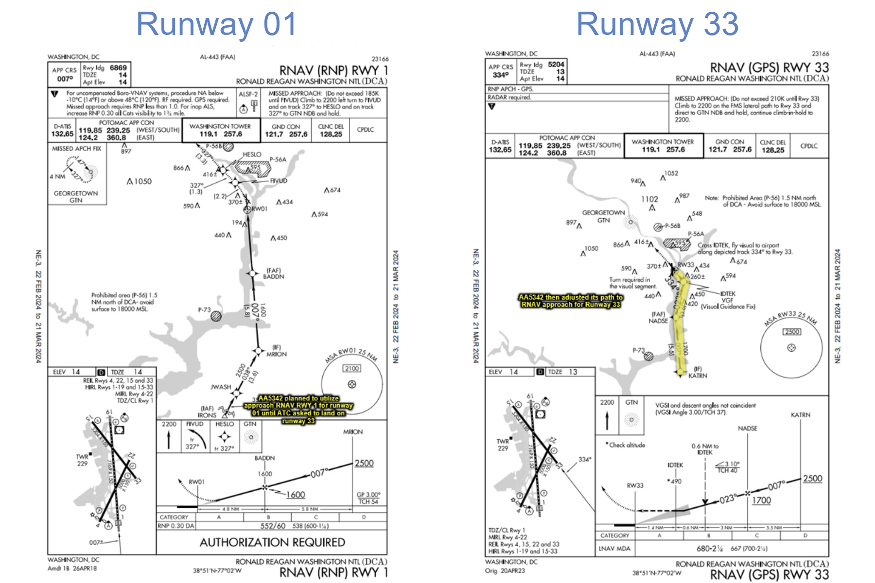
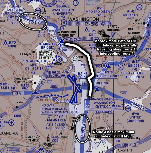
This brought AA5342 into proximity with a Black Hawk helicopter (UH-60) that was transitioning from Helicopter Route2 1 to Route 4.
UH-60 Helicopter Route (Image by FAA, Annotated by ThinkReliability)
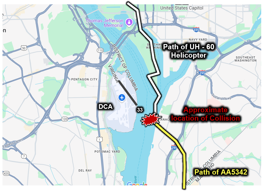
At approximately 8:47 PM, ATC asked the helicopter crew if they had visual contact with AA5342. The response was affirmative, but the crew was using night vision goggles that may have affected their ability to detect aircraft outside their direct field of view. ATC instructed the helicopter to “pass behind” the jet. Seconds later, the helicopter’s rotor blades struck the plane’s right wing, causing an explosion that put both aircraft into the Potomac.
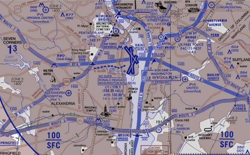
AA5342 and UH-60 Helicopter Flight Paths (Image by Google Maps, Annotated by ThinkReliability)
Initial Analysis
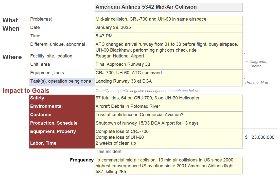
Our first step in every incident investigation is the Problem Outline. Starting with the incident’s consequences and aggregate metadata allows us to work backwards to figure out why it happened. This incident resulted in 67 fatalities, making it the deadliest U.S. commercial aviation incident since 265 lives were lost on American Airlines Flight 587 in 2001. It also caused the complete loss of two aircraft at an estimated cost of $23 million.
AA5342 DCA Mid-Air Collision Problem Outline
Next, we’ll begin our cause-and-effect analysis with a 5-Why Cause Map™ diagram to provide a basic understanding of the initial causes of the incident.
AA5342 DCA Mid-Air Collision 5-Why Cause Map™ Diagram
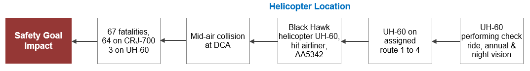
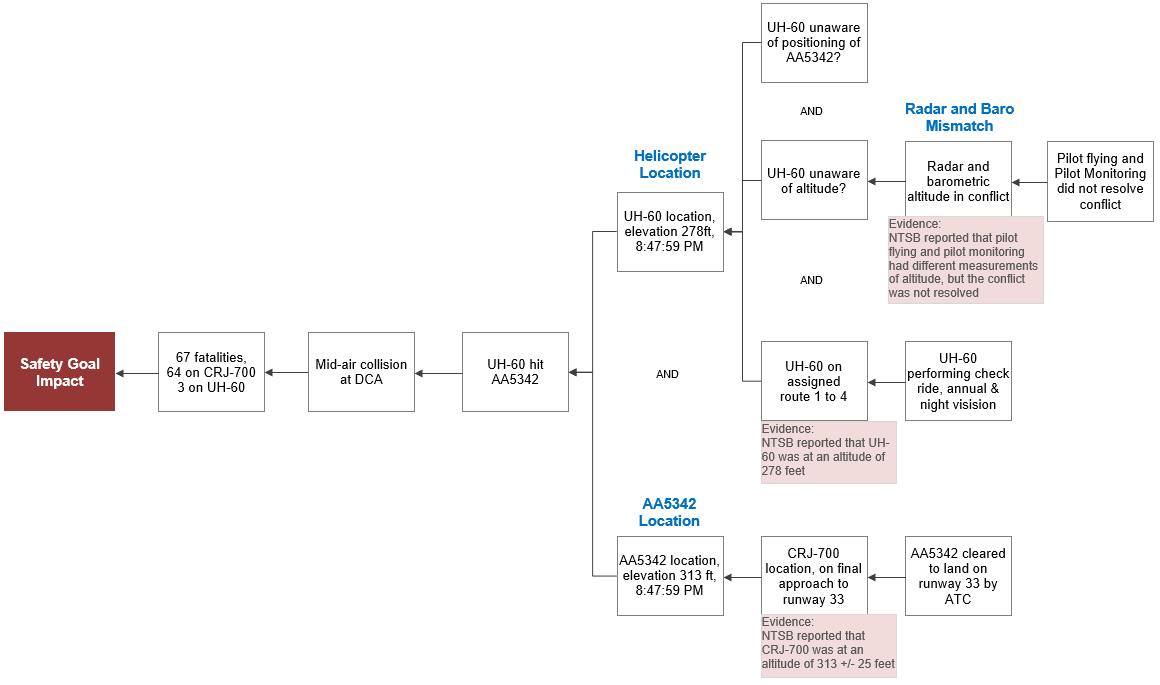
This 5-Why Cause Map diagram is accurate but only provides a partial explanation. Starting with the 5-Why establishes a baseline that can be expanded to reveal additional causes. In this case, we know that in order for the helicopter to hit AA5342, the two aircraft had to be in the same place at the same time. This allows us to expand our analysis to a 6-Why Cause Map diagram.
AA5342 DCA Mid-Air Collision 6-Why Cause Map™ Diagram

At 8:47:59 PM, both aircraft were not only at the same location but also at nearly the same altitude: the helicopter was at ~278 ft, and AA5342 was at ~313 ft.
Why were the aircraft at these altitudes? AA5342 was at 313 ft because it was on its final approach, cleared to land by ATC.
The cause of the helicopter’s altitude is a bit more complicated. Long story short, the helicopter had a discrepancy in altitude. But the details are fascinating and have only recently come to light. Let’s dive in.
Earlier in the flight (8:43:48 PM), the pilot flying the Black Hawk helicopter indicated that they were at an altitude of 300 ft. The helicopter instructor pilot, who was monitoring, indicated that they were at 400 ft. There was no further communication about this discrepancy, suggesting a possible conflict between barometric and radar altitude readings.
At the point where Helicopter Route 4 crosses the approach path for Runway 33, there is only 35 to 75 feet of vertical separation, depending on where the aircraft is located along the route.
Cross-Section of Route 4 and Runway 33 (Image by NTSB, additional annotation by ThinkReliability)3
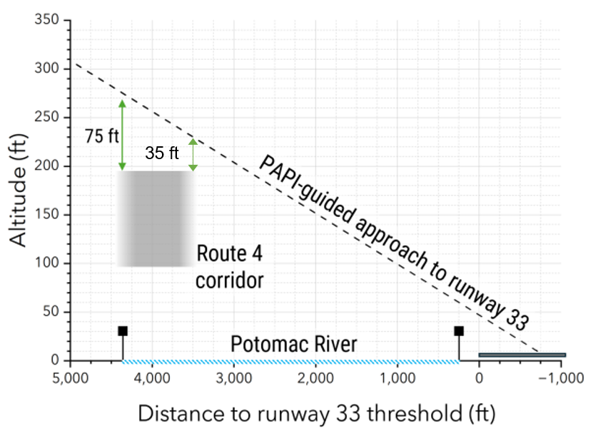
Given the radar error and barometric discrepancy, it’s not surprising how this situation unfolded. What remains unclear is whether this issue stemmed from a mechanical problem or pilot error. Notably, FAA Barometric Altimeter Errors and Setting Procedures4 state that if an altimeter reading differs from the known field elevation by 75 feet or more, its accuracy is considered questionable and should be evaluated by a repair station.
ATC had two critical conversations with the helicopter.
At 8:46:01 PM, ATC advised the helicopter of a CRJ-700 at 1,000 ft landing on runway 33. The helicopter confirmed visual contact and requested visual separation, which ATC approved.
At 8:47:39 PM, ATC again asked the helicopter if they had the CRJ-700 in sight, and the helicopter confirmed.
At 8:47:42 PM, ATC instructed the helicopter to “pass behind the CRJ.” However, recovered cockpit voice recorder data suggests the helicopter may not have received the full transmission due to a keyed mic blocking reception.
AA5342 DCA Mid-Air Collision 13-Why Cause Map™ Diagram
Immediate Reactions—and Speculation
Following this incident, the FAA took swift action by restricting helicopter flights near DCA and partially closing the route that the Black Hawk helicopter was on, as well as another route south of the Key Bridge. To reduce the risk of similar incidents in the future, these routes are now restricted to police, medical, air defense, and presidential transport flights only.
The immediate reactions from the public and politicians, however, focused on blame. Many were quick to point fingers at military operations, air traffic control, and even the pilots’ race and gender. These speculative discussions became so heated that, to this day, they continue to cloud the true story of what happened. People still ask me about factors that have long been ruled out as causes of the incident, such as ATC staffing and DEI hires.
We’ve seen this pattern before. A tragedy occurs, and people naturally want answers. But the rush to find a single “right” answer fuels misinformation, which then takes root in the public imagination. After Malaysia Airlines Flight MH370 disappeared, conspiracies dominated the conversation long before investigators had the full picture. Similarly, after Ethiopian Airlines Flight 302 crashed, many focused solely on Boeing’s MCAS system, overlooking other factors.
Early speculation distracts from the real systemic issues that need to be addressed to prevent future problems. It’s crucial to focus on what we do know, rather than jumping to conclusions about causes. Remember that incidents result from many things breaking down, not just one cause. The goal of analyzing incidents isn’t to win an argument—it’s to make sure tragedies like this don’t happen again.
What’s Next?
On March 11, the NTSB issued two urgent recommendations to the FAA:
- Prohibit operations on Helicopter Route 4 between Hains Point and the Wilson Bridge when runways 15 and 33 are being used for departures and arrivals, respectively, at DCA.
- Designate an alternative helicopter route that can be used to facilitate travel between Hains Point and the Wilson Bridge when that segment of Route 4 is closed.
These recommendations address the factors that led to the Black Hawk helicopter operating on routes near arrivals on runway 33 and departures on runway 15. This is highlighted in the newly revised DCA helicopter route charts. As you can see in the graphics below, routes near the airport have been eliminated and new cautions have been added.
Pre & Post-Incident Helicopter Route Charts, Helicopter Routes 4, 6, and 7 (Images by FAA)
These route changes effectively address the immediate problem. Additionally, discussions are underway to improve military aircraft altitude verification and refining air traffic control procedures to better confirm visual separation. We expect the NTSB to recommend additional solutions that will tackle broader concerns identified in the Cause Map diagram. With the investigation still ongoing, the NTSB will continue to examine three key questions:
- What could the Black Hawk helicopter crew see with their night vision goggles?
- Were the altitude readings accurate?
- How effective were the communication and confirmation procedures between ATC and the pilots?
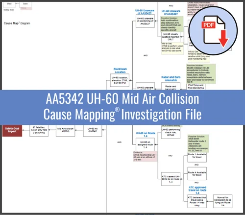
For a more comprehensive analysis of what we know thus far, download our interim Cause Mapping® investigation file. I look forward to your thoughts. Stay tuned for an update when more information becomes available.
Understanding and analyzing complex incidents like this requires a structured approach that goes beyond speculation. Our Cause Mapping Root Cause Analysis Public Workshops teach a practical, evidence-based method for investigating problems and identifying solutions. Whether you're in aviation, healthcare, manufacturing, or any other industry, learning how to systematically break down incidents can help prevent future failures. Join us in an upcoming workshop to strengthen your problem-solving skills and drive lasting improvements in your organization.

1 - TRUPS FIVE is not an acronym, it is the name of the waypoint to assist in landing.
2 - Helicopter Route Charts are used when operating in high density traffic areas.
3 - PAPI stands for Precision Approach Path Indicator, a system of lights that provides visual guidance to pilots on their approach angle to the runway.
4 - FAA Barometric Altimeter Errors and Setting Procedures


